Ofbeeldienge:Map borderline at sea Norway Russia.gif
Grootte van deze voorvertoning: 384 × 599 pixels. Andere resoluties: 154 × 240 pixels | 308 × 480 pixels | 709 × 1.106 pixels.
Ofbeeldienge in een ôgere resolutie (709 × 1.106 pixels, bestandsgrootte: 265 kB, MIME-type: image/gif)
Beschrijving
| Beschrijving |
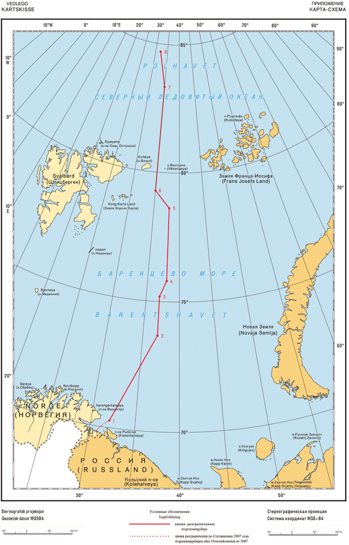
Norsk bokmål: Delelinjen i Barentshavet. |
| Datum | |
| Bron | Own work, based upon Norwegian State Departement. |
| Auteur | Original uploader wasGryphonis, based upon a work by Norwegian State Departement. |
| Toestemming (Hergebruik van dit bestand) |
Picture is of a document made by the Norwegian State Departement, with a public edict. As such, it's not copyrighted either by Norwegian nor US copyright laws. |
Licentie
| This file is in the public domain because legal statutes, administrative regulations, court decisions and other decisions by public authorities are unprotected. This is also the case with proposals, reports and other statements which concern the public exercise of authority, and which are made by a public authority, a publicly appointed council or committee, or published by the public authorities. Similarly, official translations of such texts are unprotected. Intellectual works ("åndsverk" as defined in § 2) which have not been produced specially for use in documents specified in the first paragraph, and from which parts are quoted or which are reproduced in a separate appendix, are not covered by this provision. The same apply to poetry, musical compositions or works of art.
|
 |
Oorspronkelijk uploadlogboek
The original description page is/was here.
Bestandsgeschiedenisse
Klik op een datum/tijd om het bestand te zien zoals het destijds was.
| Datum/tijd | Miniatuur | Afmetingen | Gebruiker | Opmerking | |
|---|---|---|---|---|---|
| huidige versie | 8 jun 2011 15:57 | | 709 × 1.106 (265 kB) | Gryphonis | {{Information |Description={{no|Delelinjen i Barentshavet.}} |Source=Own work, based upon [http://www.regjeringen.no/upload/UD/Vedlegg/Folkerett/100914_Kartskisse_final.pdf Norwegian State Departement.] |Date=2011-06-08 |Author=[[User: |
Bloadn met dizze ofbeeldienge
Der is/zyn verwyzieng(e)n noar dit bestand ip de volgende bloadn:
Globaal bestandsgebruik
De volgende andere wiki's gebruiken dit bestand:
- Gebruikt op ca.wikipedia.org
- Gebruikt op cs.wikipedia.org
- Gebruikt op de.wikipedia.org
- Gebruikt op en.wikipedia.org
- Gebruikt op es.wikipedia.org
- Gebruikt op no.wikipedia.org
- Gebruikt op ru.wikipedia.org
- Gebruikt op uk.wikipedia.org