Ofbeeldienge:Polish and Lithuanian Conflict with Prussia. 1377-1435..png
Grootte van deze voorvertoning: 696 × 600 pixels. Andere resoluties: 279 × 240 pixels | 557 × 480 pixels | 968 × 834 pixels.
Ofbeeldienge in een ôgere resolutie (968 × 834 pixels, bestandsgrootte: 182 kB, MIME-type: image/png)
Beschrijving
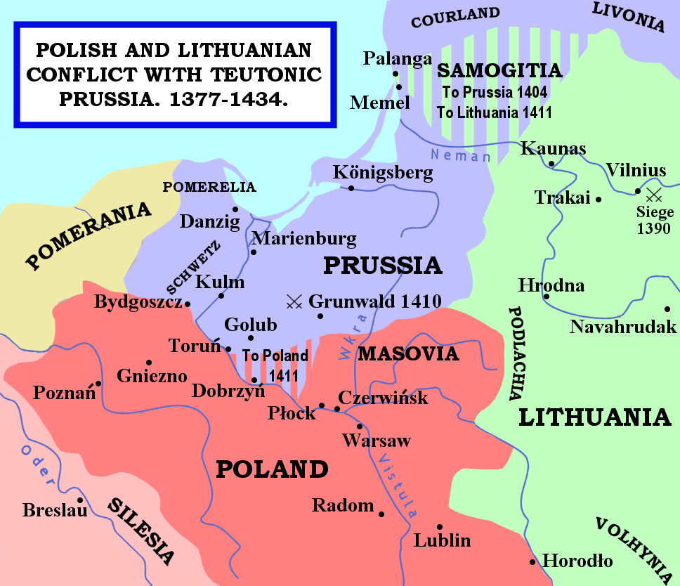
| Beschrijving | The map shows the areas of conflict between Teutonic Prussia and Poland and Lithuania during the reigns of Jogaila (Władysław II Jagiełło) and Vytautas. The areas on the borders of Prussia and Poland were particularly disputed: towns often changed hands, and Dobrzyń Land (red-and-mauve stripes) was passed back and forward as a result of various deals, treaties, and battles. Samogitia (green-and-mauve stripes) was also strongly disputed between the Teutonic Order and Lithuania, because the Knights wished to link up with the Livonian Lands further north. After the Battle of Grunwald in 1410, a series of treaties established Polish control over Dobrzyń Land and Lithuanian control over Samogitia for good, marking the beginning of the Teutonic State's decline. |
| Datum | 29 januoari 2007 (originele uploaddatum) |
| Bron | Geen machineleesbare bron opgegeven. Eigen werk aangenomen (gebaseerd op auteursrechtclaims). |
| Auteur | Geen machineleesbare auteur aanwezig. Op basis van auteursrechtclaims wordt auteur Qp10qp aangenomen. |
Sources
- The map was outlined from this old German map: Image:Poland under Jagello.jpg.
Other references:
- The Times Concise Atlas of World History, Times Books, 1994, ISBN 0-7230-0674-1, p. 56.
- Lukowski, Jerzy and Hubert Zawadzki (2001). A Concise History of Poland. Cambridge: Cambridge University Press. ISBN 0-521-55917-0. Maps on p. 36-38.
- "Baltic Europe", in The New Cambridge Medieval History VI, ed. Michael Jones, Cambridge University Press, ISBN 0-521-36290-3. Map on p. 700.
Licentie
| Ik, de auteursrechthebbende van dit werk, geef dit werk vrij in het publieke domein. Dit is wereldwijd van toepassing. In sommige landen is dit wettelijk niet mogelijk; in die gevallen geldt: Ik sta iedereen toe dit werk voor eender welk doel te gebruiken, zonder enige voorwaarden, tenzij zulke voorwaarden door de wet worden voorgeschreven. |
Bestandsgeschiedenisse
Klik op een datum/tijd om het bestand te zien zoals het destijds was.
| Datum/tijd | Miniatuur | Afmetingen | Gebruiker | Opmerking | |
|---|---|---|---|---|---|
| huidige versie | 14 feb 2007 23:22 | | 968 × 834 (182 kB) | Qp10qp | |
| 29 jan 2007 07:05 |  | 968 × 834 (182 kB) | Qp10qp | The map shows the areas of conflict between Teutonic Prussia and Poland and Lithuania during the reigns of Jogaila (Władysław II Jagiełło) and Vytautas. The areas on the borders of Prussia and Poland were particularly disputed: towns changed often cha |
Bloadn met dizze ofbeeldienge
Der is/zyn verwyzieng(e)n noar dit bestand ip de volgende bloadn:
Globaal bestandsgebruik
De volgende andere wiki's gebruiken dit bestand:
- Gebruikt op ar.wikipedia.org
- Gebruikt op ast.wikipedia.org
- Gebruikt op az.wikipedia.org
- Gebruikt op da.wikipedia.org
- Gebruikt op en.wikipedia.org
- Gebruikt op es.wikipedia.org
- Gebruikt op fr.wikipedia.org
- Gebruikt op gl.wikipedia.org
- Gebruikt op he.wikipedia.org
- Gebruikt op hu.wikipedia.org
- Gebruikt op id.wikipedia.org
- Gebruikt op it.wikipedia.org
- Gebruikt op ja.wikipedia.org
- Gebruikt op lt.wikibooks.org
- Gebruikt op pl.wikipedia.org
- Gebruikt op pt.wikipedia.org
- Gebruikt op sl.wikipedia.org
- Gebruikt op tr.wikipedia.org
- Gebruikt op uk.wikipedia.org
- Gebruikt op www.wikidata.org
- Gebruikt op zh.wikipedia.org